
Includes all content from LTS 3.39 up to and including 3.39.19.
New features
- CSW: Add support for alternative CSW sources (dublin core)
- Filter: Add support for advanced filtering of local themes
- Symbology: Admin may now style user selectable labels
Previously, an admin could choose between creating always-on labels with full flexibility in terms of styling, drawing priority, collision detection etc. Or user selectable labels, with a default style. With this PR we introduce the best of two worlds; user selectable labels that can either be default on or default off, with full flexibility in terms of styling, drawing priority, collision detection etc.Replace label layer with runtime sub for rendering labels. When selecting labels in layer manager labels are rendered with the themes configured label style.Add improved UI for configuring labels in theme/digitheme symbology:

- Symbology: Make it possible to copy colors from Colorbrewer
Colorbrewer RGB format has comma as delimiter, while Adaptive expect spaces. Added a small fix that allows an admin to copy colors from Colorbrewer directly, without having to manually reformat the entry.
- Swipe map – compare function
Add functionality to compare difference versions of theme singe theme with time dimension enabled. Open react-swipe-map module in modal

- Alternatively use dataview ReadAny for non-indexed layers
Pull data directly via dataview ReadAny if the data source is postgis/shape and the layer has not been indexed. Also fixed a bug where the configs map_search_disabled and custom_map_search would not be respected in some cases. - Elastic search indexer
This functionality is experimental.Adds new indexer/search backend, using elasticsearch as the only index storage. New indexer does not need a postgres database for management.Other nice to knows:- Scheduling responsibility is now moved to Adaptive
- Both legacy and new elasticsearch based solutions are supported, change via Web.config option
- Indexing speed is greatly improved
- Indexing does not wipe existing data before index, but deletes stale data after new index is completed
- Separate index per data set, probably avoids some of the performance issues in legacy implementation
Limitations:
- ElasticSearch geo_shape/geo_point only supports 4326. Indexer and Searcher does transformations, so this limitation is not a downgrade from legacy solution, but may still cause inaccurate results if transformations distorts bounding boxes significantly. Some measures are taken to make polygons near poles work, but they may still cause trouble.
- No shape file support yet.
Improvements
- Predefined areas: Remove epsg contraint from preset table
- Predefined areas: Add data to predefined areas from admin
- Optionally hide inactive themes from digitize button
New configurable property to delimit digitizable themes to those selected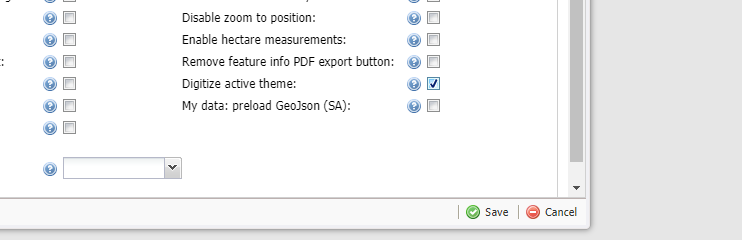
- Labels: Increase label readability
Increased map readability by swapping the current font/halo color.Before

After

- Digitheme dictionary: Check legal value for required dict fields
- Timeslider: config for setting max date to Date.now and min date in seconds from Date.now
- Collaboration module: Monitor data changes and automatically pull data
- Admin: Change visibility for multiple columns in theme editor
Sometimes you have many columns you want to configure display on. In this fix, this is resolved both for digitheme and theme. You can also ‘drag’ multiple selected rows simultaneous.
- Media: allow digi theme temp upload
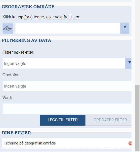
- Optionally set a theme filter on startup
Added functionality for setting a column filter through theme config. This filter will then be default active when starting the site. - Layer manager: reduce number of buttons, separate filter and metadata
Layer manager has three standard buttons (filter, label and config) that has the same action (open settings/metadata page). This PR changes this by:- Remove label button
- Separate filter and metadata/config
- Feature info: optionally hide nodata columns
Added a GUI config for hiding columns in detailed feature info not containing data. - Digi theme: Add config to skip dictionary validation
- Digi theme: PDF export settings
Theme specific settings to customize pdf report:- Filter objects by id
- Sort by column (asc/desc)
- Include/exlude media
- Show/hide empty values
- Layer dimension: add support for qgis based themes
- Adaptive style updates
- Data api: Web api alternative for dataview read/save
- Metadata synchronization: improve support for non-standard metadata layers
This PR improve support for some datasets in GeoNorge by changing the following:- Default to instance lang if lang is not provided
- Do not add if title/abstract is empty
- Parse abstract without xsi:type
- Change validation for multi select
Bugfixes
- Filter: remove reference to sid causing error when reading maps
- Filter: Fix preview before theme create
- Predefined areas: Add missing Norwegian translation
- Layer manager: Fix config page layout being squashed by scrollbar
Fix an issue where parts of the UI in theme configurator would be hidden by a scrollbar:
- Filter: Fix ambiguous reference to id column
- Theme: Do not overwrite ms_validation on save
- Filter: Only show advanced filter for themes with this feature correctly setup
- External WMS/WFS: Add FixMsValidation and Text for external WMS and WFS
- Layer manager: Restrict description lengthThis fix applies to themes where description text is synchronized from a corresponding layer on GeoNorge only. Some layer could be really descriptive. Solved this by restricting the text to 500 characters. Users can go to GeoNorge to view the entire description.Example:

kartkatalog.geonorge.no/metadata/3ffa635f-7ae1-462a-9fbb-0888eb99b8ad - Media: Cleanup filter, change netType to string[]
- Property: Fixed error for advanced export where different building-data is missing in matrikkel